")


")


BEIRUT — The number of Lebanese people abroad who registered to vote in Lebanon's May 15 elections has almost tripled since 2018, the last time the country went to the polls. As the diaspora cast their ballots this weekend, the turnover reached 59.49 percent , according to the latest figures released by the authorities.
While many expats who feel that they have been exiled from Lebanon in its ongoing economic and political freefall thing to vote for the opposition candidates, many others walked into the polling centers proudly flashing their party's logos on shirts, baseball caps and even water bottles.
The Lebanese diaspora is equally as diverse as the community still residing in the country. However, some towns and cities have a higher percentage of diaspora voters than others.
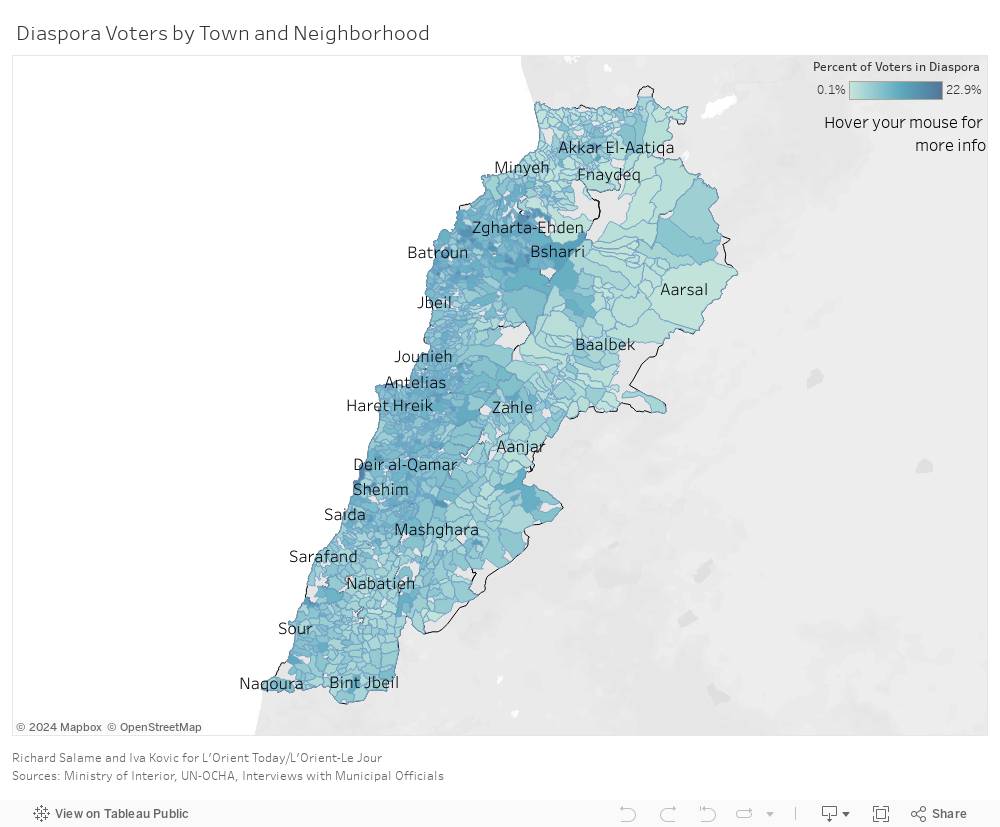
L'Orient Today mapped the voters in municipalities around Lebanon to give an idea of how significant diaspora voters' role is in each district, using voter registration files from the Ministry of Interior's official 2022 elections final release and a base map created by the United Nations Office for the Coordination of Humanitarian Affairs based on cadastral administrative boundaries from the Council for Development and Reconstruction (CDR), up to date as of Sept. 28, 2021.
The top three municipalities in terms of the percentage of diaspora voters are Dahr al-Maghara, in the Chouf district, with 22.89 percent registered diaspora voters, Kahf al-Malloul, in the Minyieh-Dinniyeh district, with 22 percent and Jouret Arsoun, in the Baabda district, with 21.6 percent.
There are 208 towns and neighborhoods around Lebanon with over 10 percent of their electorate registered to vote overseas.
Jouret Arsoun's mokhtar (local official responsible for records), Fadi Loubos, said that he believes the town's diaspora community, who are scattered across many foreign countries, went to the polls this weekend en masse.
“The expats voted as if they were still in the country. Their voices matter still,” he told L’Orient Today , adding that he hopes the diaspora who cast their ballots will help instigate change. “Everyone is tired, including myself.”
The Koura district also has a high number of diaspora voters in some of its towns, namely Dar Shmezin and Kfar Hazir, each registering 17.2 and 17 percent respectively.
The district's mayor, Najat El Zoghbi, said that she believes this election will bring about positive change, but she doubts that change will be as significant as many people expect it to be.
“Many young adults from Koura have emigrated recently, mostly to the Gulf, to Canada, to the States. A large number of them voted, too,” she said, adding that the younger generation is leaning more towards the opposition.
“People who are heavily politically affiliated in this district have rarely ever diverged or changed their minds… Each family has made a decision who to vote for; some for the opposition and some for the already established parties.”
The data in this map
The map of Lebanon’s towns and neighborhoods includes the number of registered voters in each area as well as the number and percentage of diaspora voters, the top sects represented in the area and the top countries where registered diaspora voters are found.
The Ministry of Interior voter rolls contain 1,532 place names, compared to 1,661 polygons on the OCHA map. The discrepancies between the two datasets were reconciled manually using Google maps, wikimapia, and information collected from interviews with mokhtars and municipal officials in the relevant towns.
In some cases, the CDR and Ministry of Interior’s understandings of where boundaries fall for the same area differ. In such cases all voters are represented, but the specific land area may not align. In other words, the numbers per area are accurate, but the locations of the borders between towns are not definitive.
Data is presented using the most granular level of detail possible, which is limited by the datasets. For example, although the Ministry of Interior subdivides Sour into neighborhoods on the voter rolls, OCHA’s map does not recognize the same neighborhood boundaries.
Conversely OCHA’s map divides the Baalbek village of Qaa into multiple zones, whereas the voter rolls do not divide the village into zones. In such cases subunits were merged to achieve equivalency between datasets at the cost of granularity inside one of them.