Israeli military vehicles along the border with Lebanon, June 18, 2026. (Credit: Jalaa Marey/AFP)
")


")


Four days ahead of the next round of direct negotiations between Lebanon and Israel in Washington, and as the cessation of hostilities and Israeli withdrawal from southern Lebanon are at the heart of discussions between the Israelis and the Trump administration, Israel has formalized on a new map its military occupation of parts of southern Lebanon. This time, the occupation covers areas beyond the initially defined "buffer zone" established in mid-April, along the coast, in the central sector, and in the Nabatieh region.
This new map, published by Israel's military spokesperson Avichay Adraee, outlines the borders of the Israeli army's "operation zone" in southern Lebanon, which, according to the official, stretches "ten kilometers deep" into Lebanese territory. In his statement, Adraee uses Hezbollah's presence as a pretext for Israel's continued operations in the occupied territories, saying that troops are deployed "in order to eliminate threats and improve the defense of residents in northern Israel."
An Israeli military official specified that the army could also act against any target it deemed a "risk" beyond the so-called "buffer zone," ordering civilians not to enter the area, effectively barring people from returning safely to their homes.
Compared to the map published on April 19, three areas have been extended, according to a digital comparison of both documents by L'Orient-Le Jour.
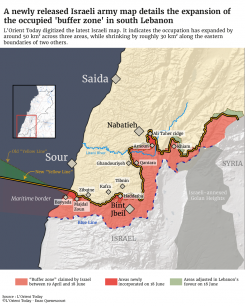
The first area includes the villages of Bayyada and Majdal Zoun (Sour) adding 11 km². The Israelis advanced into these areas, which were north of the initial "yellow line," and fighting has been reported there in recent weeks by sources from our correspondent in the South and by Hezbollah. The second area, a pocket of 16 km², includes, in the central sector, Haddatha, where a battle between the Israelis and Hezbollah lasted several days.
Israeli army vehicles were observed there on Wednesday, while residents and the Israeli army, who earlier on Thursday were attempting to clear debris, were subject to Israeli fire and forced to retreat. North of the Litani, in the Nabatieh region, the Israeli army has claimed an additional 25 km² stretching southeast of the city to the hills of Ali Taher, a strategic high position, as well as the northern banks of the river near Zawtar Sharqieh, where the Israeli army had crossed the Litani River.

The map also seems to show that some areas, totaling around 30 km², are no longer included in the "buffer zone," particularly in the Marjayoun region. While it is not yet possible to confirm whether these new demarcation lines signal a potential Israeli withdrawal from this zone, which notably includes northern Khiam, it should be noted that, on its first map, the Israeli army had placed the border town further north. The shift of the "yellow line" northward in this region may therefore be due to an adjustment of this initial localization error. However, reports from field sources indicated two days ago a movement of Israeli troops and vehicles toward the south of Khiam as well as the Sarda and Amra regions.
On the map, the land area Israel now claims covers 620 km², compared to about 600 km² on the map published in mid-April.
The maritime boundary has also been modified. While the point on the coast is further north, at Bayyada, its orientation has changed, which seems to reduce it. With this new inclination of the maritime "yellow line," the Qana gas field once again appears to be divided between the Lebanese and Israeli exclusive economic zones.
This article originally appeared in French on L'Orient-Le Jour.