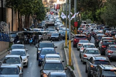

Israel's unprecedented mass displacement order for the entirety of Beirut's southern suburbs on March 5, 2026, caused massive traffic jams across the city. (Credit: Claudia Greco/Reuters)
")


")


On Thursday at 3 p.m., time in Beirut took on a different pace after Israel issued a mass evacuation order — illegal under international law — for residents of the entire southern suburb of the Lebanese capital, encompassing four major neighborhoods.
An evacuation zone of this scale is unprecedented in the context of wars between Israel and Hezbollah. It is more reminiscent of Israeli practices in Gaza, when it ordered the evacuation of more than 85 percent of the enclave which led to the forced displacement of nearly two million Palestinians.
Let’s take a closer look, using maps and figures, to grasp the magnitude of this forced displacement, unprecedented in the history of Israeli wars on Lebanon.

More than 23 km2 ordered with forced displacement
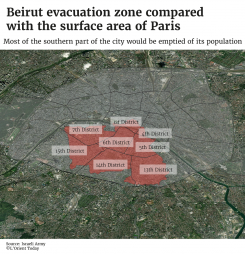
The size of the area Israel ordered with evacuation is larger than the entire city of Beirut, which covers 19 km².
If we compare the evacuation area to other cities in the world, it would correspond to most of the southern part of Paris (the Left Bank) or over a third of Manhattan in New York.
Approximately 700,000 residents forced to flee
This is more than half the population of central Beirut in 2021 (1,290,000 residents), according to data from the United Nations.
In fact, the southern suburbs of Beirut (locally known as Dahieh) constitute the most densely populated area in the Beirut metropolitan area. While the average density of the entire urban area of Beirut is about 19,500 residents per km², the neighborhoods of Haret Hreik and Burj al-Barajneh, at the heart of Dahieh, reach around 35,000 residents per km².
Eight percent of Lebanese territory affected by Israel's unprecedented evacuation order
According to calculations by L’Orient-Le Jour, 855 km² of Lebanon are affected, including 832 km² in the south of the country — that is, the entire area between the Litani River and the Blue Line, which serves as a buffer zone with Israel — and 23 km² in the southern suburbs of Beirut.
For a small country like Lebanon — whose area is comparable to the French department of Gironde, around Bordeaux — and which covers about 10,000 km², this therefore represents nearly one-tenth of its territory.
Four localities affected by the evacuation order in Beirut's southern suburbs
The evacuation order issued by the Israeli army explicitly mentions the neighborhoods of Burj al-Barajneh, Haddath, Haret Hreik, and Chiyah. However, the map that accompanies the evacuation order — and which L’Orient-Le Jour has reproduced above — does not perfectly match the administrative boundaries of these neighborhoods, but also concerns other areas, either in whole or in part.
If we are to stick to the text issued as part of Israel’s evacuation order, the neighborhoods affected are as follows:
- Haret Hreik: a predominantly Shia neighborhood in the southern suburbs of Beirut, this neighborhood is fully included in the evacuation zone. As a result, two hospitals were urgently evacuated, Bahma and al-Sahel, and their patients were transferred to other hospitals in Beirut.
- Chiyah: a densely populated, predominantly Shia neighborhood in the southern suburbs. The entire neighborhood is affected by the evacuation order.
- Haddath: a city on the southern outskirts of Beirut with a majority of registered Christian voters, mostly Maronites, fully included in the evacuation zone.
- Burj al-Barajneh: a predominantly Shia, working-class neighborhood in the southern suburbs, adjacent to a major Palestinian refugee camp. The entire neighborhood is targeted by the evacuation order.
The Israeli strikes on the southern suburbs of Beirut on the night of March 5 to 6 affected only the localities of Haret Hreik, Chiyah, Burj al-Barajneh, and Ghobeiry.
This article originally appeared in French on L'Orient-Le Jour.