


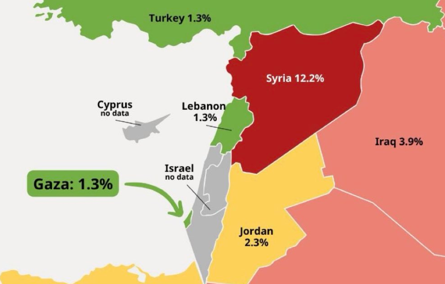
A map of the Middle East published on August 6, 2026 by the official X account of the Israeli Ministry of Foreign Affairs shows a part of southern Lebanon annexed by Israel. (Credit: Photo Telegram/@StateofIsraelOfficial)






BEIRUT — The Israeli Ministry of Foreign Affairs published a map on its X account on Aug. 6 that contained numerous errors, including what appeared to show part of southern Lebanon as annexed to Israel. The publication quickly prompted official Lebanese protests to Washington before being deleted by the Israeli ministry from the platform over the past 24 hours. However, the same map was published Sunday on the official Telegram account of the Israeli state, where it was still visible on Monday.
The map also shows Lebanon extending eastward into Syrian territory. This significant expansion gives the impression that southern Lebanon has been cut off in favor of Israel. The map appears to show this in the western part of southern Lebanon, although not conclusively. In the eastern sector, however, the opposite appears to be the case: Lebanon clearly extends into part of the Galilee and now shares a border with the West Bank. The West Bank, meanwhile, has expanded westward at Israel’s expense, while the Golan Heights have been returned to Syria to the east.
Other geographical inaccuracies appear on the same map, including the absence of a shared border between the Gaza Strip and Egypt, the Israeli Negev appearing to border the Mediterranean, and the island of Cyprus being placed significantly farther south.
The map is intended to illustrate the level of malnutrition in several countries in the region and support Israel’s claim that there is no famine in the besieged and largely destroyed Gaza Strip, following the Israeli offensive launched after Hamas’ Oct. 7, 2023, attack on Israel.
"A new study commissioned by UNICEF shows that the food situation in Gaza — contrary to all propaganda — is now better than that of all neighboring Arab countries, and even some European countries," Tel Aviv says in the accompanying text. The study in question finds that that "crises linked to food security and child nutrition persist in Gaza despite some fragile progress," while UNICEF confirmed for the first time a "famine" in the Palestinian enclave in August 2025.
'What happened does not reassure us'
An official Lebanese source told L’Orient-Le Jour on Monday that President Joseph Aoun had “contacted the Americans as well as other parties” and “exerted pressure on this issue,” which initially led to the removal of the English-language version of the publication containing the map. The map remained visible for a time on the Arabic-language X account of the Israeli Ministry of Foreign Affairs before also being removed, the source added. “What happened does not reassure us and seems to reveal Israeli intentions,” the source said.
Contacted by L’OLJ, the Lebanese Foreign Ministry did not respond to requests for comment.

According to the Lebanese site al-Modon, Lebanon's ambassador to the United States, Nada Hamadeh, in turn contacted the U.S. State Department to convey Beirut's position and ask Washington to intervene with Israel to have the map removed.
In the framework agreement signed June 26 between Lebanon and Israel under Washington’s auspices, Tel Aviv says it has “no territorial ambitions in Lebanon.”
Respect for Lebanese borders
Hezbollah reacted Sunday to the Israeli map, saying it “unambiguously confirms the reality of Israeli ambitions regarding Lebanon, its territory, its wealth and its resources — ambitions that Israel has not given up on and will not give up on.” According to the group, Israel’s participation in direct negotiations with Lebanese authorities “is nothing but a blatant attempt to buy time and impose new facts on the ground.”
In a statement particularly critical of the Lebanese authorities, Hezbollah called for an end to direct negotiations with Israel and action on the political, diplomatic and legal levels. It also called for an emergency meeting of the Higher Defense Council and for Lebanon to file a complaint with the U.N. Security Council.
The deletion of the map on X does not appear to have closed the matter for Beirut. According to al-Modon, Lebanese authorities want to put the issue on the agenda for the next round of negotiations with Israel — which may not take place, as Lebanon recently threatened to suspend direct talks with the Israeli state.
Beirut is seeking a clear and unambiguous position from Israel regarding respect for Lebanon’s international borders. The issue is all the more sensitive as the Israeli army continues demolition operations and earthworks in southern Lebanon despite the cease-fire that came into effect in mid-June with Hezbollah.
This article was updated on Aug. 11 to reflect further details about the inaccuracies and errors in the map.

 7 p.m. recap: 1 person killed near border with Lebanon; 200 kilos of explosives carried by mules; Riyadh shuts its airspace