

(Credit: Enzo Quenescourt)
")


")


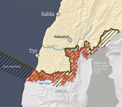
On April 19, the Israeli army outlined the parameters of an “advanced security zone” it intends to impose in south Lebanon before a permanent cease-fire.
According to L’Orient-Le Jour's data, the area spans around 602 square kilometers — roughly 5.8 percent of Lebanon’s territory — and includes 62 towns and villages.
")
The plan effectively bars residents from returning home to these areas.
In the absence of a reliable census, L’Orient-Le Jour based its estimate on 2022 electoral rolls, indicating that at least 200,000 adults are now forced to leave their homes. The figure does not include residents under 21, who are not registered on voter lists.
The Israeli army has not yet deployed to all of these localities. Based on field analysis, it had occupied 47 villages as of April 21.
")
The southern Christian villages — Rmeish, Ain Ibl, and Dibil — are surrounded by Israeli troops, who have not yet entered them.
In the eastern sector, the Shiite villages of Kounin, Ma'ibb, Tallouseh, and Beni Hayyan have suffered significant destruction and have been subjected to heavy Israeli fire since the cease-fire, but are not currently under sustained occupation. Yohmor is, to date, the only locality north of the Litani River included in the buffer zone and has not been captured.
The villages north and east of Khiam, also within the perimeter, are likewise, for the time being, outside the reach of the Israeli army. In fact, the village above Khiam, Ibl al-Saqi, is predominantly Druze — a religious group traditionally treated with care by the Israeli army.
Israeli-occupied villages within the “buffer zone”
- Bint Jbeil district (13)
Ainata, Aitaroun, Aita al-Shaab, Beit Lif, Bint Jbeil, Hanine, Maroun al-Ras, Qouzah, Rshaf, Ramieh, Tiri, Yaroun - Marjayoun district (17)
Odaisseh, Adsheet al-Qoussair, Arab al-Louaizeh, Blida, Deir Mimas, Deir Siryan, Houla, Houra, Kfar Kila, Khiam, Markaba, Mais al-Jabal, Qantara, Qsair, Robb Thalathin, Sarda, Taybeh - Sour district (16)
Alma al-Shaab, Boustan, Shamaa, Shihine, Dhaira, Bayyada, Hamoul, Jibbayn, Jijim, Labbouneh, Marwahine, Matmoura, Naqoura, Tayr Harfa, Yarin, Zalloutieh - Hasbaya district (2)
Majidieh, Wazzani
Villages within the “buffer zone” without Israeli troop presence
- Bint Jbeil district (4)
Ain Ibl, Dibil, Kounin, Rmeish - Marjayoun district (6)
Alman, Ain Arab, Beni Hayan, Ibl al-Saqi, Mohaibib, Tallousa - Nabatieh district (1)
Yohmor - Hasbaya district (3)
Shebaa, Mari, Khreibeh - Rashaya district (1)
Ain Ata
 Five Lebanese soldiers injured by 'suspicious object' as Israel continues demolitions in the South