Lebanon's 13 reserve points along the blue line. (Credit: Guilhem Dorandeu)
")


")


As Israel announced on March 11, 2025, the creation of "three joint working groups" with Lebanon — focusing on five recently Israeli occupied points, the Blue Line and remaining disputed areas — we invite you to revisit this article, originally published on May 12, 2024.
The marking of the Lebanese-Israeli land border has been at a standstill since Sept. 13, 2023. On that day, the last tripartite meeting between Lebanon, Israel and the U.N. Interim Force in Lebanon (UNIFIL) took place in Naqoura, southern Lebanon, with no agreement reached on 13 contentious points along the Blue Line, the demarcation line.
However, with Hezbollah’s involvement in the Gaza war since Oct. 8, the issue has resurfaced prominently in negotiations led by the United States and France for a lasting settlement between Lebanon and Israel.
The finalization of the land border demarcation constitutes the third stage of the proposal by US envoy Amos Hochstein, complementing the plan submitted by the French to the Lebanese authorities.
To assess the progress on this matter, L’Orient-Le Jour assessed the situation with Lebanese Army General Khalil al-Gemayel, who served as commander of the southern Litani sector from 2016 to 2017. During his tenure, he led troops along the Blue Line and was responsible for coordinating with UNIFIL to implement Resolution 1701. Currently, he is pursuing a doctorate at the Lebanese University focusing on the delineation of maritime borders in the Middle East and its implications for the Lebanese maritime border.
Is the land border issue almost resolved on a technical level, as some political figures are saying?
The marking of the Blue Line stopped in 2018. However, the issue has been frozen since September 2023, a month before the Gaza war. The last tripartite meeting ended with the following conclusion: No agreement was reached between Lebanon and Israel. The dispute remains unresolved.
What is the dispute about?
The dispute revolves around two main aspects, with the commissions responsible for determining the route working within 25 centimeters of each other.
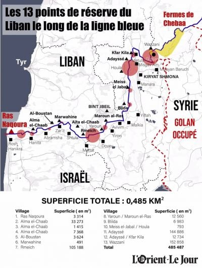
Firstly, it involves the final route of the Blue Line encountering 13 points contested by Lebanon. During the marking of the Blue Line with the United Nations, Lebanon expressed reservations regarding the location of each of these points, which would result in a loss of nearly half a square kilometer of territory, specifically totaling 485,487 square meters.
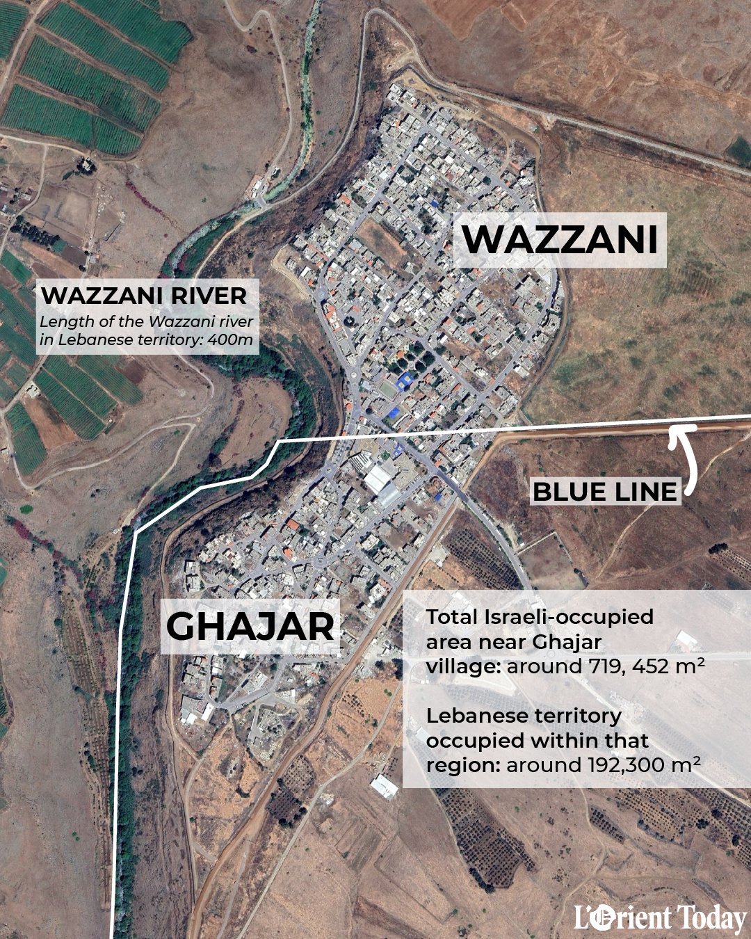
In 2000, when the Israeli army withdrew from the south, Lebanon initially raised objections at three locations: Rmeish (105,188 m2), Odaisseh (144,886 m2) and Wazzani (152,858 m2).
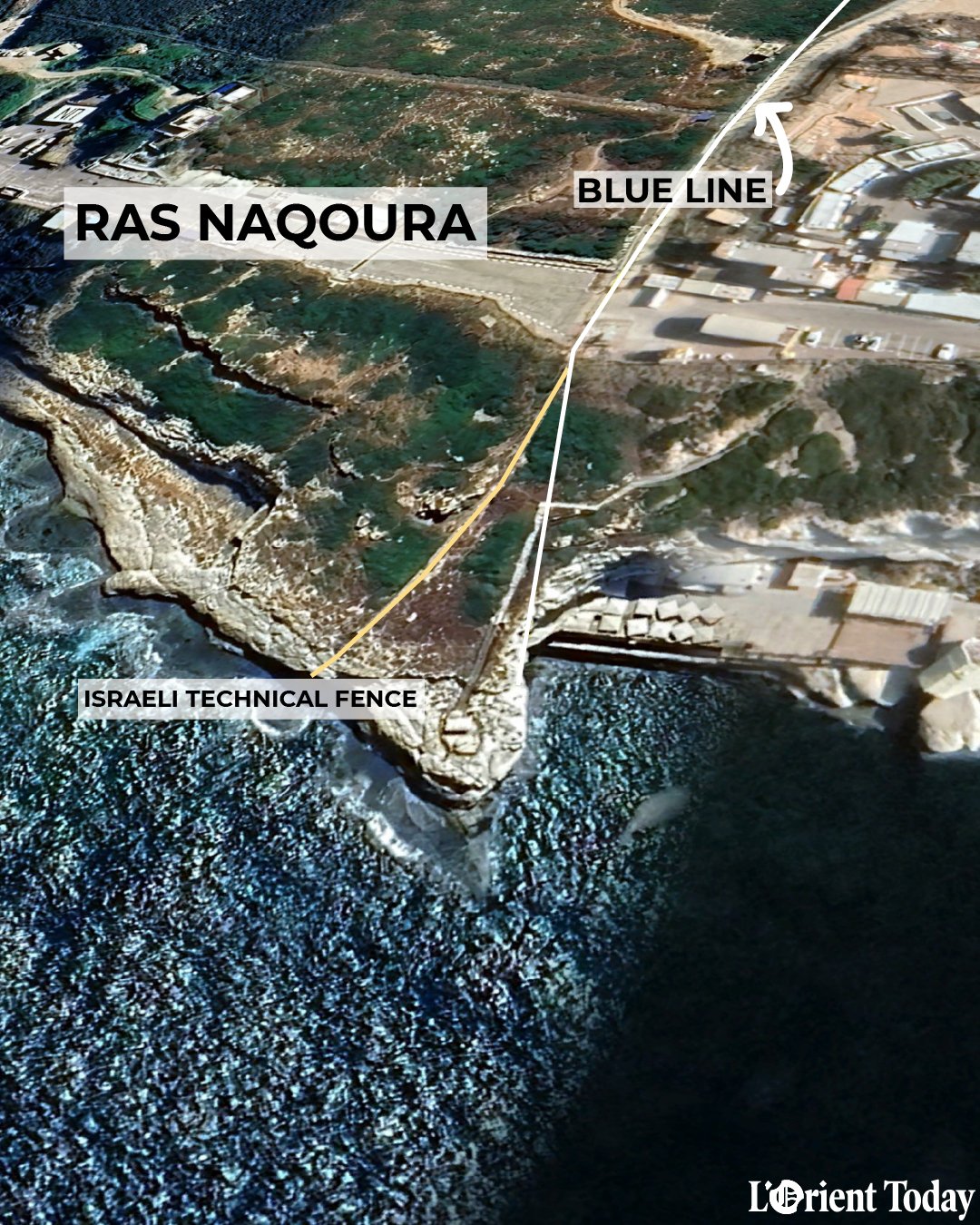
After the Israeli offensive in 2006, the UN provided the Lebanese authorities with a digital format of the Blue Line. After conducting surveys from Naqoura to Wazzani, the Lebanese Army identified reserves at 10 additional points, though of considerably smaller surface area. These 10 points are in Ras Naqoura, Alma al-Shaab (3 points), al-Boustan, Marwahine, Yaroun, Blida, Mais al-Jabal and Kfar Kila.
 (Credit: Jaimee Lee Haddad/L'Orient Today)
The second aspect pertains to ongoing Israeli encroachments into Lebanese territory. The Lebanese Army has documented 18 violations, some of which coincide with reserved points.
In certain areas, like al-Boustan, the violation involves simply crossing the Blue Line and erecting a technical barrier to safeguard two Israeli military bases and the neighboring villages. Conversely, in places such as Ras Naqoura, Israel constructed a cable car and a tourist resort above a tunnel claimed by Lebanon.
From Odaisseh, the Israeli town of Misgav Am, once situated on the Lebanese-Israeli border, now appears distant when observed from the balcony adorned with the “I Love Odaisseh” sign, where locals often take photos.
The challenge arises as the point marked by Lebanon intersects with the town of Misgav Am. Altering this arrangement proves to be a complex task.
Further to the east, the most recent encroachment documented concerns the area of al-Meri, the Lebanese section of the village of Ghajar occupied by Israel and subsequently developed by its inhabitants with Israeli consent.
Between the reservations and the ongoing violations, there are currently 25 unresolved points spanning an area of 1,222,013 square meters. Since March 17, 2018, the Supreme Defense Council has deemed the reserved areas occupied territories.
On what basis did Lebanon make reservations and declare violations?
Lebanon expressed its reservations due to discrepancies at 13 points between the Blue Line established in 2000 and the armistice line resulting from the agreement signed between Lebanon and Israel on March 23, 1949, under UN Security Council Resolution 62, following the first Arab Israeli war [May 1948-March 1949].
This binding agreement mandated a cease-fire and an armistice between the warring parties, requiring them to delineate an armistice line and withdraw their forces accordingly.
Lebanon remains bound by the armistice agreement, which serves as the foundation for all subsequent UN resolutions pertaining to Lebanon and Israel. Resolutions 425 and 426 called upon Israel to completely withdraw from the territories of southern Lebanon invaded in 1978, while Resolution 1701 was adopted following the 2006 conflict between Israel and Hezbollah.
The armistice line follows the international borders between Lebanon and Palestine, delineated by the Franch-British Paulet-Newcombe (PN) Mandate Committee in 1923, following the aftermath of the First World War and the collapse of the Ottoman Empire.
This committee was tasked with demarcating the borders between Lebanon and Palestine, as well as between Syria and Palestine. It identified 38 points in Lebanon [out of a total of 71 points], extending from border point one [BP1] at Ras Naqoura to border point 38 [BP38] at Wazzani, although these two points were not considered the endpoints of the border. However, the Paulet-Newcombe line lacked precision.
Decades later, when demarcating the armistice line, 105 intermediate points were added to the original 38 border points to enhance precision and continuity.
These border points [BP] were further supplemented by points B, beginning from B1, situated between BP1 and the sea. However, it’s important to note that while B1 serves as the starting point for the maritime border, it is not considered the starting point for the land border line.
Each marked point on the ground corresponds to a map with precise coordinates and accompanying written documentation. As a result, the armistice line is significantly more precise than the original PN line.
Ideally, the Paulet-Newcombe (PN) and armistice lines should align, as stipulated in the texts. However, that is not always the case.
Due to decisions made during the mandate period and conflicts between Lebanon and Israel, Lebanon contends that it lost seven villages covering an area of 74 square kilometers to Palestine in 1923. These villages include Ibel Kamh, which became Yuval; Hounine, which became Margaliot; Nabi Youshah, which became Ramot Naftali; Qadas, which became Yiftah; Malkiyé, which became Malikah; Salha, which became Yiron and Afikim; and Tayr Bikha, which became Choumra.
Furthermore, Lebanon asserts that it later ceded approximately 16 square kilometers of land to Israel across the eight regions of Rmeish, Yaroun, Aitaroun, Blida, Mais al-Jabal, Houla, Odaisseh and Kfar Kila.
What is Lebanon’s exact position?
The armistice line is recognized as the official border line, and thus, the Blue Line should coincide with it. The Lebanese land border was established in 1923, making it a century-old delineation with data registered at the United Nations.
Consequently, Israel is obligated to remove its technical barriers and retreat to the armistice line. Additionally, it must cease its efforts to alter the disputed points.
For instance, the adjustment of point B1 by approximately 30 meters on Israel’s part could have implications for maritime borders. Disagreements over this point contributed to the cessation of Blue Line marking in 2018.
Could a political decision change the situation?
Preserving the data registered with the United Nations is imperative, and any alteration to this data must be strictly prohibited. Moreover, clandestine agreements are unacceptable, as each tripartite meeting generates reports from both the Lebanese and Israeli sides, which are submitted to UNIFIL for registration.
To date, 268 points out of approximately 500 have been mutually agreed upon by both parties. Blue barrels, comprising 256 barrels and 12 flags, have been installed at these points to delineate the Blue Line. Any deviation from this agreement would require the consent of the Lebanese Parliament.
Is the border town of Ghajar a special case?
Lebanon asserts that Israel’s continuous encroachment upon the village stems from its occupation of the area after crossing the Blue Line. In Ghajar alone, this violation encompasses an area of 719,542 square meters.
The village is effectively divided by the Blue Line: One part lies within the Syrian Golan Heights, annexed by Israel in 1981, while the other part is situated within Lebanese territory. Israel occupied the portion within Lebanese territory during the July 2006 war and subsequently sealed it off in July 2023.
The population of the village, consisting of approximately 2,000 individuals from the Syrian Alawite community, predominantly opted for Israeli nationality during the 2000s.
However, Lebanon alleges that Israel has effectively divided the village, sealing off the road to prevent any connection with Lebanon and facilitating construction.
Ownership of Ghajar remains a subject of dispute among the three countries Lebanon, Syria and Israel.
 (Credit: Jaimee Lee Haddad/L'Orient Today)
This article was originally published in L'Orient-Le Jour. Translated by Sahar Ghoussoub.
 Tensions mount around strategic Ali Taher hill in south Lebanese district of Nabatieh