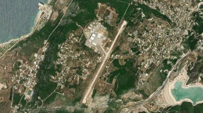
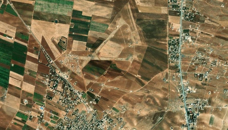
A satellite photo showing Hamat airport in North Lebanon. (Credit: Screenshot/L’Orient-Le Jour)
")


")


How many runways and airfields can a country with a surface area of a bit over 10,000 square kilometers contain? While the Rafic Hariri International Airport and the Riyaq military air base are well known to the Lebanese, many may be surprised to hear that there are other airfields across the country, most of which have fallen into oblivion, barely surviving in collective memory. Yet these infrastructures tell the story of the ups and downs of Lebanese history.
L’Orient-Le Jour takes you back in time to the origins of these airfields and airports.
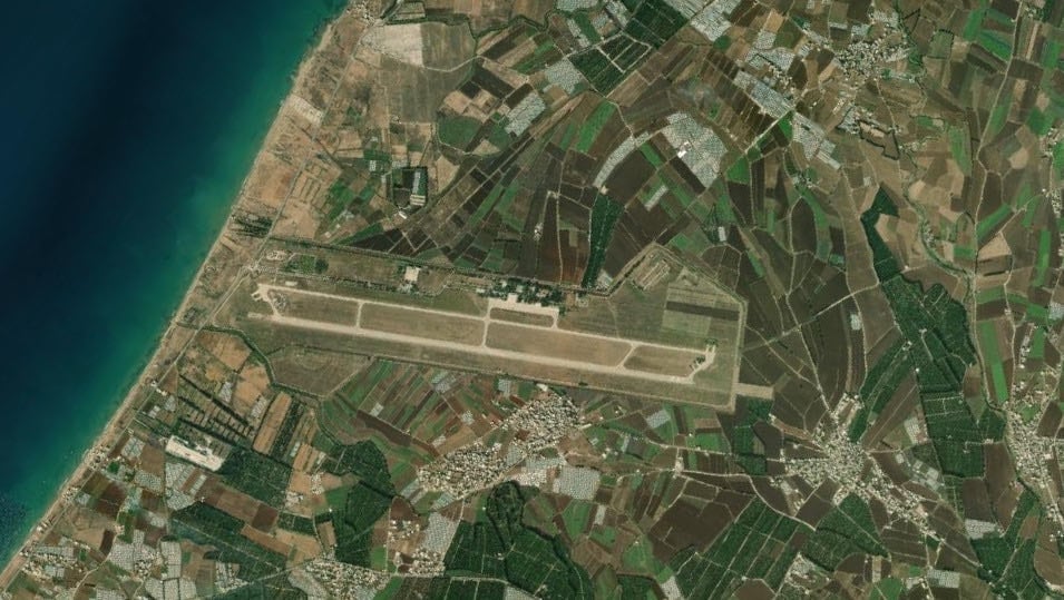
The Riyaq military base, in operation since 1914
In 1914, the Riyaq air base in the Bekaa Valley was nothing more than a dirt runway drawn by German airmen deployed in Palestine. In 1920, the French army took control of the site and set about making it the most modern air base in the region. German aircraft began landing there again in 1940, thanks to a collaboration between Vichy France and the Nazi regime. The base finally came under the control of the Lebanese Army in 1943. The Lebanese airforce was created in 1949 and still takes charge of the air base today. It currently houses the army’s flight school and a special forces training center.
 Riyaq military base. (Credit: Screenshot/L’Orient-Le Jour)
Marjayoun, crucial during World War II
The last remnants of the Marjayoun air base — a few stones and a few dirt tracks — are a reminder of the strategic importance of this part of southern Lebanon, located at the crossroads between Lebanon, Palestine and Syria. Crucial during World War II for controlling the advancement of the Axis troops, the runway did not survive the departure of the British army.
 The Marjayoun air base. (Credit: Screenshot/L’Orient-Le Jour)
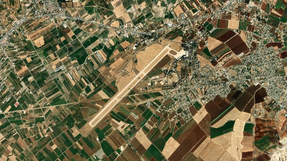
Will Qleiaat be open to domestic flights one day?
The Qleiaat airfield was built by the French army in 1938. Still in operation in the 1960s, it was used by the Tripoli oil company, which used it to transport its employees between Lebanon and Iraq. After a brief interlude, the Lebanese Army took control of the runway in 1966 and began modernizing it — that was until the Syrian army intervened and kept control of the airfield until 2005, when it withdrew from Lebanon. The respite was short-lived, however, and in 2006 the airfield was bombed by the Israeli army, which systematically targeted Lebanese runways. After repairs, the Lebanese airforce once again took control of the site. Discussions began in 2010 to transform what is now the Rene Moawad air base into a domestic and international airport serving as a transit point for domestic flights and international low-cost airlines, but the project never materialized.
 The Qleiaat airfield. (Credit: Screenshot/L’Orient-Le Jour)
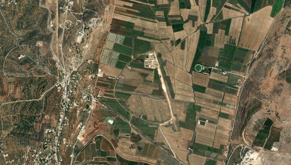
Iaat, from the army to Hezbollah
Built by the Allies during World War II, the Iaat runway, north of Baalbeck in the Bekaa Valley, had only a brief history. Employed by the Lebanese air force from independence in 1943, it closed its doors for good in the 1960s. However, the Iaat name was once again associated with military aviation in 2014, when satellite images revealed that Hezbollah had set up a drone airport not far from the old runways.
 The Iaat runway, north of Baalbeck. (Credit: Screenshot/L’Orient-Le Jour)
Halat, a Christian airport on a motorway
In January 1987, the Lebanese Forces bombed the Beirut airport located in the western part of the capital, rendering it unusable. Behind the bombs was the desire to force the hand of international partners to turn the Halat military air field into an airport open to civilian flights. The problem was that it was nothing more than a stretch of motorway hastily converted into a runway by the Lebanese Army in 1976. Since the start of the Civil War a year earlier, the Lebanese Army has lost control of its air bases, such as Riyaq military base, the home of the Lebanese air force, which was by then under the control of the Syrian army.
Located 28 kilometers north-east of Beirut, the Halat runway was opened using a section of the motorway linking the capital to Tripoli. While the war lasted, the facilities on the site were developed, partly financed by the al-Mashreq bank, which was close to the Kataeb, and made the base a functional, if not safe, airfield. However, the project for a civilian airport in a Christian zone never saw the light of day: the runway was too short and the proximity of the surrounding buildings made it almost suicidal for civilian aircraft to use it. In 1991, the runway was finally reconnected to the motorway and the airfield was soon forgotten.
 The Halat motorway airport. (Credit: Screenshot/L’Orient-Le Jour)
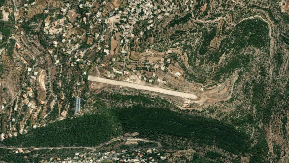
Baadaran, the mountain airfield
The Baadaran runway takes its name from the Chouf village where it is located, not far from Mukhtara. Located at the top of the Chouf mountains, it owes its existence to the Progressive Socialist Party. In the early years of the 1975-90 Civil War, the short 850-meter runway was intended to enable the Druze to have their own airport, in addition to the port of Khaldeh. Although enlarged in 2007, the runway is no longer used for civilian or military flights, but rather for tourists, concerts and model aircraft enthusiasts.
 The Baadaran runway. (Credit: Screenshot/L’Orient-Le Jour)
Jounieh and Hamat, ephemeral runways
In 1975, a simple dirt runway was laid out in Jounieh to accommodate military traffic diverted from Beirut airport. Being too rudimentary, the runway was only used for a year before it was replaced by the Hamat runway.
The latter, named the Pierre Gemayel International Airport, never fulfilled the functions promised by its name. Built at the instigation of the Kataeb in 1976, the Hamat runway was intended to accommodate both civilian and military flights. But even before it was completed, it came under the control of the Syrian army, which used it for its helicopters. In 2005, the Lebanese Army regained control of the site, using it for the same purpose.
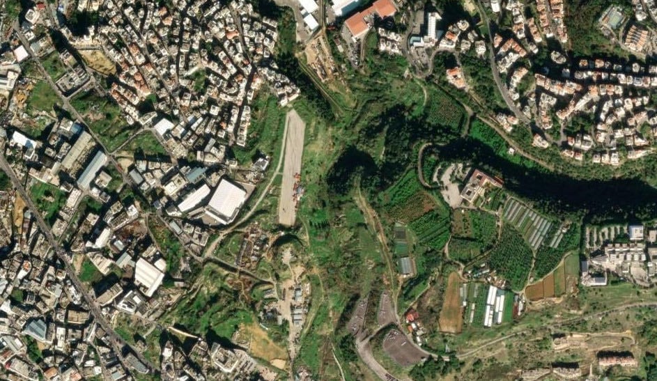
Dekwaneh, the forgotten runway
The small Dekwaneh runway may have become a popular strolling zone for some local residents, but it is not widely remembered for its military function. Very close to the former Palestinian camp of Tal al-Zaatar, it is too short to have any significant military use. Its construction and abandonment dates are unknown.
 The Dekwaneh runway. (Credit: Screenshot/L’Orient-Le Jour)
This article was originally published in French in L'Orient-Le Jour. Translation by Joelle El Khoury.